Vaitape in two or three days: the ring road, the lagoon and Mount Otemanu

Last updated 8 October 2026
Overview
Vaitape is Bora Bora’s only town, and the island wraps around it as a single road: a ring circling the lagoon, with the jagged spike of Mount Otemanu behind it the whole way round. There is no neighborhood to choose the way there would be in a city — the only real questions are how far you go each day, and how much of it is spent in the water rather than on the road. Two days cover the two things Bora Bora is actually for — the beach at the southern tip and the lagoon itself — and a third adds the parts of the island most visitors drive straight past without stopping.
There is no scheduled public transport here. The one thing this route needs that the parent guide will not sort out for you is wheels: a rental scooter, bike or small car, picked up in Vaitape on the morning you start — in season, ask your pension to reserve it the evening before — because the ring road is the route, and nothing on this itinerary is a walk between places.
One clock matters more than any other, because day one ends by it: the sun sets across the year from around half past five in June and July to about a quarter to seven in December. Matira Beach, the day’s anchor, is built to be watched from at that hour — take your month, and count back from whichever end of that range it falls closer to.
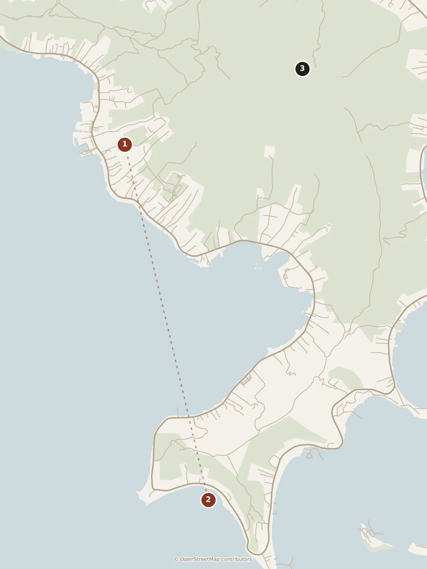
- Day one
- 1Vaitape
- 2Matira Beach
- Day two
- coral garden — in the prose, not on the map
- shark and ray site — in the prose, not on the map
- a motu — in the prose, not on the map
- With a third day
- 3Mount Otemanu
Day one

Everything today runs one way, south down the western side of the island, so it never doubles back on itself.
Morning
Most flights land on the motu that holds Bora Bora’s own airstrip, separate from the main island, and every one is met by a boat — the short crossing that actually delivers you, docking at Vaitape’s quay in fifteen to twenty minutes over flat lagoon water. That crossing is the true start of the day, whatever time your flight says.
Vaitape itself is small enough to see on foot in the time it takes to collect your rental: the quay, the market stalls set up behind it, the church at the top of the square, and the roundabout beyond that most of the island’s traffic starts from. Eat here if you can get it — a paper cone of firi firi, the fried dough twists sold hot at the market stalls in the morning, is the thing to have standing up before you get on the road. Give the village the better part of an hour; there genuinely isn’t more of it, and that is not a complaint about the place, just its size.
Afternoon
From the roundabout the ring road runs south along the coast, lagoon on your right for the whole stretch. Reckon on twenty to thirty minutes of driving rather than the ten the distance alone would suggest — it is a single lane for most of its length, shared with everyone else on the island, and nobody drives it fast. Stop for lunch somewhere along this stretch, or once you reach the south end: poisson cru, raw fish cured in lime juice and coconut milk, is the dish to order here, and it is on every menu that faces the lagoon.
The road runs out at the southern tip, where Matira Beach begins — Bora Bora’s one public beach, the only stretch of sand on the island that does not belong to a hotel, and the reason the day is built to end here rather than pass through for an hour. The sand curves and faces west, out over open lagoon with nothing between it and the horizon, which is what makes the evening work.
Evening
This is the moment the whole day is arranged around, so count backward from it: the village costs the better part of an hour, the drive south another half hour on top of that, lunch by the water another hour again — call it two and a half hours spent before you are free on the sand, whatever time that leaves you starting from. Everything after belongs to Matira Beach itself: swim, walk the curve of it, or just sit and let the last hour run down. When the light has gone, ride home the way you came — the short western leg, not the unlit loop round the east. Because it faces west with nothing in the way, this is the one place on the island where the sunset is the whole view rather than something you catch at an angle past a motu or a hotel roofline.
Local tip. If the rental only takes a full tank back, fill it in Vaitape before you set off, not on the way. Past the village there is nowhere else on the ring road to do it, and running short on a single-lane road with nowhere to turn round is a worse problem here than it would be almost anywhere else.
Day two
Today does not touch the ring road at all. It is booked rather than driven, and the boat does the moving.
Morning
The day starts at whichever quay your pension arranges — usually the same wharf at Vaitape, sometimes a jetty closer to where you are staying — with a boat rather than a rental. This is the day almost everyone on the island does in some form, and for good reason: it is the lagoon, not the land, that Bora Bora is actually built around, and today is the only point on this route where you see it properly.
First stop is the coral garden, a shallow patch of reef inside the lagoon where a gentle current does the moving for you rather than the other way round — you drift over it rather than swim actively, which is why it comes first, while everyone still has the patience for something slow. Give it thirty to forty minutes; it rewards an unhurried pass far more than a long one.
From there the boat moves to a shallower site further out, where rays gather in numbers you will not see anywhere else in the lagoon, and blacktip reef sharks work the same shallow water alongside them — small, genuinely reef-dwelling sharks that keep their distance and are made more of than they need to be. It is waist-deep water the whole time, not open sea, and the guide wading in ahead of you is doing exactly what you are about to do.
Local tip. If your boat gives you a choice of order, ask for the shark and ray site before the coral garden rather than after. It is the stop people are most nervous about, and doing it while the morning is still fresh beats saving it for the end of the day.
Afternoon
Lunch is on a motu — one of the small sand islets scattered along the lagoon’s outer reef — and it is almost always included in whatever you booked rather than bought separately once you land on it. Po’e, the sweet baked pudding made from mashed banana or pumpkin under coconut cream, is the thing to hope turns up on the table; it reads as a dessert rather than a main course, and on a lunch like this that is exactly the right register.
The rest of the afternoon is unstructured on purpose: more time in the shallow water off the motu, or simply sitting on sand that most of the island’s hotels charge guests to look at from a distance. There is no second stop to time this against — the boat brings everyone back to Vaitape in the later afternoon, and that closes the day without any further planning needed.
Evening
Back in Vaitape as the light starts to go, with nowhere further to be. An early night suits this evening better than a late one, since the third day, if you take it, opens with the longest single stretch of driving on the whole trip.
With a third day

Give it to the side of the island the first two days do not show you. The ring road continues north and east past Matira Beach, and Mount Otemanu — the basalt spike at the center of the island, all that survives of the volcano that built it — sits at your shoulder for the whole drive rather than across the lagoon the way it did on day one.
There is no single stop to aim the morning at; the drive itself is the point. Slow down wherever the road opens out and the peak clears the trees, which happens several times on the eastern side, where the coast pulls back a little from the water. Give the loop two to three hours at an unhurried pace, more if you stop often, and there is no reason on this island not to.
That leaves the rest of the day, and it splits two honest ways. The straightforward one is to go back to Matira Beach: you have already done the sunset arithmetic once, the beach rewards a second afternoon as much as a first, and nothing about it depends on the weather holding. The other is a guided hike into the island’s interior, up towards the ridges below Mount Otemanu itself, which is real and worth doing but genuinely conditional — most of the interior is private or agricultural land, so it is not a walk you start on your own, it has to be arranged through your pension or a local guide in advance, and the paths turn to mud and are sometimes called off outright after heavy rain. If you want it, book it before you commit the rest of the day to anything else, and treat the beach as the fallback rather than the plan if the weather turns against it.
Either way the day ends where the first one did, on the west-facing sand at Matira Beach, for whichever end of the sunset range from the Overview your visit falls into — and, as on day one, the ride home after dark is the short western leg, not the loop.
Practicalities
Book the lagoon excursion before you arrive if you can, or as early as possible once you are on the island — it fills, especially around the middle of the day. The shared full-day trip, usually with the motu lunch included, is one of the larger costs of a stay; ask what is and is not included when you book, and compare your pension’s price with the operator’s own, since that is what varies most between operators.
If you are adding the interior hike to the third day, arrange that one separately and earlier still. It depends on both a guide and the weather holding, and it is the one part of this route that can genuinely fall through. Have the beach ready as what you do instead if it does.
Nothing else on this route keeps hours the way a museum or a church would: the beach, the ring road and the lagoon are all open air and unticketed once you are on them. The only closure that matters here is the weather, and it only ever touches the third day.
Everything on days one and two is on wheels or on water rather than on foot, so there is no walking distance worth giving between stops — the ring road is the route, and nobody drives it end to end on the same day they walk it. The one exception is Vaitape itself, small enough to cover on foot in the time it takes to collect a rental.


.jpg)

.jpg)